


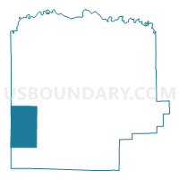
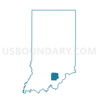
MADISON, Washington County, Indiana
About
Outline

Summary
| Unique Area Identifier | 581185 |
| Name | MADISON |
| County | Washington County |
| State | Indiana |
| Area (square miles) | 26.09 |
| Land Area (square miles) | 26.04 |
| Water Area (square miles) | 0.05 |
| % of Land Area | 99.81 |
| % of Water Area | 0.19 |
| Latitude of the Internal Point | 38.50743680 |
| Longtitude of the Internal Point | -86.26337780 |
Maps

Graphs
Select a template below for downloading or customizing gragh for MADISON, Washington County, Indiana


Neighbors
Neighoring Voting District (by Name) Neighboring Voting District on the Map
- HOWARD, Washington County, IN
- SOUTHEAST, Orange County, IN
- STAMPERS CREEK, Orange County, IN
- VERNON, Washington County, IN
- WEST POSEY, Washington County, IN
Top 10 Neighboring County Subdivision (by Population) Neighboring County Subdivision on the Map
- Posey township, Washington County, IN (1,888)
- Southeast township, Orange County, IN (1,603)
- Howard township, Washington County, IN (1,262)
- Stampers Creek township, Orange County, IN (954)
- Madison township, Washington County, IN (705)
- Vernon township, Washington County, IN (669)